 Overview
This hike loops around the summit of Bear Mountain, passing several spectacular viewpoints.
Details
Time:
1 hours
Difficulty:
Easy to Moderate
Length:
1.3 miles
Route Type:
Circuit
Dogs:
Allowed on leash
Features:
Views, Handicap Accessible, Historic feature, Woods
Location
Park:
Region:
County:
Orange
State:
NY
Buy Trail Map:
Web Map:
 Buy Book:
First Published:
Updated/Verified:
Submitter:
Daniel Chazin
Photo
Trail Conference volunteers maintain trails in this park.
Trailhead GPS Coordinates
41.311612, -74.007235Driving Directions
Take the Palisades Interstate Parkway to Exit 19 (Perkins Memorial Drive/Bear Mountain Park) and continue along the Seven Lakes Drive. In one mile, make a very sharp left turn onto the Perkins Memorial Drive and follow it for two miles to a parking area at the top of Bear Mountain, at the base of the Perkins Memorial Tower.
Description
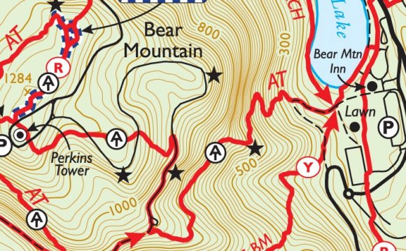
This hike follows a newly-built section of the Appalachian Trail (A.T.), formally opened in a ceremony on Saturday, June 4, 2011. As part of a multi-year project to reconstruct this heavily-used section of the A.T., a team of professional trail builders, together with Trail Conference volunteers, created a magnificent footpath that takes full advantage of the natural features of interest found along the trail.
 The hike begins at a sign for the A.T. on the northwest side of the summit. Directly ahead is a fork. The blue-blazed fork to the left will be your return route, but for now, take the right fork, blazed with the 2"x6" white blazes of the A.T. and the red-ring-on-white blazes of the Major Welch Trail. The first third of a mile has been designed to be handicapped-accessible, thus permitting all users to enjoy a beautiful section of the A.T. Even this trail section has been skillfully designed to blend in with the surroundings.
In 500 feet, you’ll cross a gravel service road. To the right, atop a massive boulder, are the concrete foundations of a former fire tower (replaced in 1934 by the Perkins Memorial Tower). Then, a quarter mile from the start (after crossing another service road), you’ll come to another huge boulder on the left side of the trail.
At the end of this boulder, the Major Welch Trail departs to the right at a fork, but you should bear left and continue to follow the white-blazed A.T.
After passing the end of a blue-blazed trail on the right, you’ll reach a spectacular north-facing viewpoint over the Hudson River and the hills of the West Point Military Reservation, with Brooks Lake visible directly below. This marks the end of the accessible trail section. After taking in the view, bear left and descend stone steps. Ahead, you will see a stone pillar that once marked the boundary between the park and West Point.
The trail again curves sharply to the left and begins to head south through dense mountain laurel thickets, with an understory of blueberry. This section of the A.T. features many stone steps, most of which were shaped on-site from native rock. In a quarter mile, you’ll pass two huge boulders to the left, with stone steps curving up from the end of the second boulder.
RELATED VIDEO


Share this Post
latest post
-
 Bear Mountain Inn Reviews July 20, 2024
 -
 Bear Mountain Discount lift tickets July 10, 2024
 -
 Bear Mountain tickets Deals June 30, 2024
 -
 Bear Mountain California Map June 20, 2024
 -
 Bear Lodge Mountains Wyoming June 10, 2024
 -
 Bear Mountain Season Passes May 31, 2024
 -
 Bear Mountain New York hiking May 21, 2024
 -
 Big Bear Mountain weather 10 day forecast May 11, 2024
 -
 Bear Mountain Coupons May 1, 2024